
Exploration: the action of traveling in or through an unfamiliar area in order to learn about it.
Oxford Dictionary
I enjoy reading books about the early polar explorers, the Voyageurs, modern adventure seekers recreating an historic trip from the past and even people trying to homestead on a small piece of wilderness they have managed to call their own. Tales of these adventures touch some internal primal desire I have for the risks and rewards that come living outside modern conveniences. Bikepacking trips kindle the embers of that same innate spirit of exploration that smolders within many of us. Even the planning for a trip is exciting. I enjoy pouring over maps and satellite imagery to help draw routes, fussing over a gear list, packing, editing and repacking bikepacking bags. Looking at the forecast offers the opportunity to test my fortitude and clothing choices while riding challenging terrain in all kinds of weather.

While bikepacking is an escape from our day-to-day routines, these trips force us to be present as we move through the natural world at a pace that is both fast enough to cover a lot of ground but slow enough to interact with our surroundings. Although we have far fewer interactions with other people than in a typical workday, we have time to talk to and learn about the few new people who do cross our paths and the small towns where they live.
Being immersed in nature, filtering water, warming yourself by a campfire and sharing those experiences with close friends is so restorative. Taking the time and making the effort to try to learn from what the plants, animals, and physical world have to teach us can be incredibly impactful.

With its plentiful supply of low-traffic forest roads, fire lanes, logging roads and two-track, Northeastern Wisconsin is a great place to plan such adventures by bike. When you add the many lesser-known waterfalls in the area to the adventure, it is even grand. Thanks to Shane Hitz for this great route and story. I’ve ridden much of this route and visited many of these same waterfalls on one of the early recon trips for the Wisconsin Waterfall Loop recently published here and on bikepacking.com. Some of the photos here are mine and some I got from Shane. I added photos of the mining museum in Iron Mountain even though Shane didn’t visit it on this trip. There is also a cool Glider Museum right next to the mining museum. We’ll save those photos for another visit.
I first met Shane Hitz five years ago when he came along on the Tour de Chequamegon bikepacking trip I organize every fall. Like me, Shane was bit by the bikepacking bug and enjoys planning routes to explore the unpaved world around him. For that, he is fortunate to live in the Wausau area, where he has many urban escape routes that offer quick access to backcountry bikepacking routes and a core group of friends happy to tag along on his adventures.
I went with Shane and his pals on a Tour de Nicolet a couple of years ago and enjoyed the well-planned route and company. With its ski hill, whitewater kayaking course, progressive mountain bike trails, great breweries, and farm-to-table restaurants, Wausau is becoming the Chamonix of Wisconsin. With Shane and his friend and backcountry buddy Chris Shotz scheming together, it is destined to become a bikepacking epicenter. I hope you enjoy his story and get a chance to ride this great new bikepacking route.
— Seeley Dave

Trip planning and bike choice
Each year for the past three years I have planned a different waterfall route and invited a few of my friends to go with me and explore these new waterfalls. To plan the route, I use resources such as looking through publications on the web such as gowaterfalling.com for the more popular falls and use map layers on Ride with GPS to locate and mark lesser-known falls, other points of interest that are close by and create the route we will follow. For the routes, I try to use as many unpaved roads and trails as possible, while still passing through small towns to resupply and eat at local restaurants and taverns.

My ideal route will contain numerous two-track and singletrack trail sections. The 2021 route through Northeastern Wisconsin fits these criteria perfectly. It features a bonanza of deep sand forest roads, a couple of sections of singletrack in the Iron Mountain area, plenty of gravel, and connections to small towns. Because some of these small towns are off the main highways, they get few visitors outside of people that might have vacation or hunting property nearby.
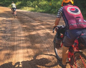
While the route was dialed, this year Mother Nature made the adventure a little more challenging for the three of us. The forecast called for rain off-and-on through the three late August days of our trip. Getting wet from a warm late summer rain wasn’t the concern but it can make the soft gravel roads and miles of sand sections slow going.
For this reason, I chose to ride my fat bike with 4” tires while Chris Schotz and Candace Jenkins brought bikes fitted with 2.7” tires. This proved to be a good choice as the first day was light rain for most of the ride. Sand on this route, especially scattered throughout the first 165 miles, was plentiful and our setups made going through it a breeze and so much fun. Chris and Candace had to lower the pressure on their narrower tires once we reached the deep sand roads, while I ran a firm 16-18 psi on my four-inch tires.
On the last day, Forest Road 608 challenged us with a constant chain of nearly hub-deep puddles from the heavy storm that rolled through the previous night. The puddles were followed by a long climb on a two-track paved with baby head rocks. Between all of that was the singletrack in Niagara and Iron Mountain. But bikepacking with a fat bike encourages you to slow down and tends to make the singletrack a chill affair.
That said, one of the more memorable moments of the trip that would not have happened if we were on narrower gravel tires was the three of us racing as fast and hard as we could through Spread Eagle Barrens. The rolling hills of the barrens were formed by glaciation with sandy outwash with some fun corners. At the end of that three-mile section, we were drenched with sweat and laughing so hard, leaving us with an amazing memory for sure!
The waterfalls

The route is a loop that passes by 15 waterfalls and three sections of rapids. We started out in the rain on the first day, so we skipped McClintok Park and Strong Falls. Both are interesting places to see, especially McClintock Park with its many bridges.
After those, we visited an unnamed waterfall up a bit from Horseshoe Falls on the Pike River. The sand forest road leading to it soon turned to two-track, which eventually became a seldom-used hunter track and a dead-end with a loop where UTVs turn around. The height of the grass told us that no one had been there in a very long time. We were now between about half a mile from where I dropped the POI on RideWithGPS I placed from being able to visibly see the falls with satellite imagery.
No trail through the forest and no audible sound of the falls could be heard but we did see two red ribbons tied to trees as we bushwhacked our way towards the POI using the downloaded route on the RideWithGPS app on our phones. Soon we started hearing the rush of the water and knew we were on the right track. When we came to it we were in awe. The combination of the beauty of the falls and knowing we were three of the very few people that made it back there to witness it was very rewarding.
Being the adventurous soul that Chris is, he jumped in the river to get a better picture of the falls. Something he repeated many times on the trip.
Dave’s Falls, Bull Falls, and Horseshoe Falls were next in the route. After that was Twelve Foot Falls and Eight Foot Falls where we watched a guy raft over after he drank a Hamm’s beer. Eighteen Foot Falls was just down the road from there, which is an impressive waterfall that requires a short hike to get to. Five miles down the road we came to a bridge where far below is the impressive Carney Rapids which has a log lengthwise jammed in it. We all agreed that the log looks like it was felled with ax and wondered if it could still be a remnant from the first logging era in time.


Someone driving past in a car might miss this impressive canyon. By bike more of our senses were alert and we were drawn to look by the sound of the rapids rushing below. Right next to the rapids a dead-end takes you to Four Foot Falls. The road to the falls is amazing, and as Candace said at the time, “it seems like we’re riding through a jungle.”
With the river rushing to our right on the way in, we noticed small waterfalls every so often. At the end of the road is a small hiking trail consisting mostly of a new boardwalk that leads to the falls. This waterfall is not large but has a unique drop to the side caused by a large crevice in the rock running lengthwise with the stream.
Twenty-six miles later we came to Long Slide Falls. This is an impressive falls with its height and rock formations. Just up the road a mile or two is Smalley Falls, my favorite of the route. The verdant forest around Smalley Falls makes you feel like you’re in the jungle with its trees and ferns growing out of the side. You can actually climb down and easily get right into the falls and even take a dip in the deep pool at the bottom, as Chris did of course.
After we crossed the border into Michigan and rode the singletrack, we sat on the rocks with our bikes laying next to us to look at Piers Gorge while eating some snacks we brought from the previous town. Candace and Chris were splitting a pancake that they brought from the diner earlier that day. I had some toast from that diner and squeezed the jelly packets on it that I grabbed from the diner table. Ordering extra food at stops is a great idea and makes for memorable picnic moments like this one. From there we rode a few miles to the roadside Fumee Falls, which is small but beautiful.


We skipped Pine River Falls so we could make it to camp before dark. The first thing after breaking camp the next morning was an early visit to LaSalle Falls. This is the largest drop in the area with a 20’ plunge and a one-mile hike on a well-worn trail. Shortly after is the last waterfall on the route, Washburn Falls, a small drop on a wide and wild river that then becomes calm and tranquil. Having a long distance between services we filtered water at this spot out of the crystal clear Popple River, a fitting way to say goodbye to the last of the falls of the trip.
Food and Camp
Some of my favorite places to eat are restaurants, taverns, and cafes in small towns that I find while bikepacking. Over the years I’ve come across places that smoke their own meat, places with amazing lake views, and places where I ended up talking to the owner like we were old friends. Candace has a good rule of thumb when it comes to finding local favorites; go to the place with the most vehicles in the parking lot.
Winter’s Family Restaurant in Pembine, was an incredible place for breakfast. This place was close enough to camp at only 20 miles out. It was nice to not have to cook breakfast that morning at camp. I tend to eat a lot, and this place doesn’t skimp on the portions or the flavor. I ordered their special of the day, a giant skillet that was smothered in gravy. Candace ordered two of the biggest pancakes I’ve ever seen. They were so big that she only was able to eat a third of them. Chris ordered a giant omelet. We are still not sure how many eggs were in it.

The hospitality Up North is always top-notch. Winter’s went through the trouble of packing up the remaining of Candace’s pancakes in foil and then ziplock bagged it so she could pack it with her on the bike! She said it made a great afternoon lunch for her and Chris to share. I ended up bagging up my toast and grabbing a couple of jelly packets off of the table for my afternoon lunch.
On the way out we got stopped by two guys asking about our trip. They ended up being from the Iron Mountain area and told us the best way to ride the singletrack at Piers Gorge. Other than gas station food the only other place we stopped for a meal was 51st State Brewing in Iron Mountain. The place just got a new pizza oven so we ordered a pizza to share. The pizza was delicious and the beer went down easy after a long hot day in the saddle.
For camping, our first night was at Twelve Foot Falls campground. They have about 15 sites and we actually were lucky enough to get the last one that was available. The best thing about that campground is listening to the sound of the waterfall while drifting off to sleep.

The second night we really had to push it to make it to our planned camping spot before dark. The small three-site dispersed campsite is on a slow-moving part of the Pine River just before the dam. That night the sky was completely clear, and watching the Milky Way overhead and watching lightning storms roll through just to the north of us made for quite a show. During the night we did have a storm with heavy winds roll through. Although it only lasted half an hour, it sure added a bit of excitement to the night.
There are a few other campgrounds that I have labeled with POI markers on the RideWithGPS map, most notably Bear Lake Campground, Goodman Park Campground, Morgan Park Campground, and West Bass Lake Campground.


No Comments